


I still have a few more posts to add to my “long gradients” series—moving on to the experiences of other patterns and places, since I think I’ve said all I have to say for now on how they might be represented photographically or otherwise. But having recently finished my orchestrated version of The Last Island (click the image to the left and then hit play on youtube if you haven’t had a chance to watch/listen yet!), and toying with the idea of proposing it and “musical cartography” more generally as subjects of a talk for this fall’s NACIS conference, I’m taking a break from long gradients to write a few music-oriented posts. I’ll wait till the next post to focus on The Last Island—how I structured the piece based on spatial ideas about the geography it evokes as much as my relatively limited musical composition/theory training. The post you’re reading now will be more theoretical, thinking about a general framework of how musical, visual, and geographical space interact. While it might turn out not to have much bearing on the next post, it’s been necessary for me to work through that thinking.
The purpose of these two music-themed posts is mainly to organize my thoughts and possible ways of presenting them, and to get a sense of the ideas’ potential from my own perspective and also maybe yours. I know these recent musings have been on the drier, academic side—frankly I’d never intended to shy away from that sort of thing in this blog—but don’t worry, imagery from incredible parts of the world will soon make its way back into the mix!
Musical vs. Physical Space
I’ve often thought about how musical “space” relates to physical space, whether the latter is three-dimensional (the “real world”) or two-dimensional (maps, photographs, and other depictions). At first thought music as a medium seems distinct in that it relies on the temporal dimension—music couldn’t exist if time stopped. But if you think about it a bit more, this apparent distinctiveness isn’t right: Your visual (or tactile, olfactory, etc..) experience of a place, or of a visual representation of that place, is no less about the passage of time than a musical representation of that place would be. Hiking in the Grand Canyon, standing still at the edge of the Grand Canyon while exploring it with your eyes, or exploring a photograph of the Grand Canyon with your eyes are all essentially equivalent to “exploring” it by listening to Grofé’s Grand Canyon Suite—all are explorations that have duration, just made using different senses. These different modes of exploration are also tied up in Mussorgsky’s Pictures at an Exhibition, inspired by the composer’s ambling through an art gallery. His physical act of walking, the movement of his eyes over each painting, and someone else’s listening to the piece are all parallel or intermingled temporal experiences (though the musical version likely condenses or extends the duration of the physical experience).
Of course the physical, visual experiences of the Grand Canyon and art gallery do have crucial spatial aspects, in 2D and/or 3D, that the musical experiences don’t. But music does have spatial components, whether that’s the physical 3D space of a concert hall or the 2D form of the printed musical score. Those are obviously different things than the 3D canyon or gallery, or 2D paintings of the canyon or in the gallery. But being the over-thinking person that I am, I was interested in figuring out how these different types of physical form and space “line up,” in the same way that the progression of time in listening to a piece of music corresponds to the time taken to experience a physical place or visual representation of that place.
The rest of this post will address this question with regards to a particular real place that I’ve talked about before (the island of La Gomera in the Canaries), the visual representation it inspired me to create (Divide), and a hypothetical musical composition inspired by my experience of that visual representation and in turn by the real place. The Last Island—even though it incorporates a musical composition I’ve actually written—wouldn’t work for laying out this theoretical framework because the imaginary island it’s based on doesn’t exist in the form of a map/worldview.

Aerial photograph of La Gomera, Canary Islands (Google Maps).
(Psycho-) Geographical Space
If you ignore the vertical dimension (elevation/altitude), the two dimensions describing the “real” island of La Gomera are of course length/distance—whether that’s degrees of latitude and longitude, meters, or some other unit. Together these dimensions form “geographical space.” Within that space an infinite number of environmental elements—elevation (as measured by contour lines), temperature, precipitation, species composition, etc…—that vary with distance can also be measured. An aerial photograph of the island, no matter how “accurate,” is technically a map—it leaves out tons of information, makes “decisions” about color and the like, and is a flat representation of the earth’s curved surface. Even your view of the island from a parachute would be a mental map of the place—your eyes and brain would be making various decisions and distortions. But since the goal of the image isn’t to reflect human prejudice or experience, think of it here as representing “the real place.”

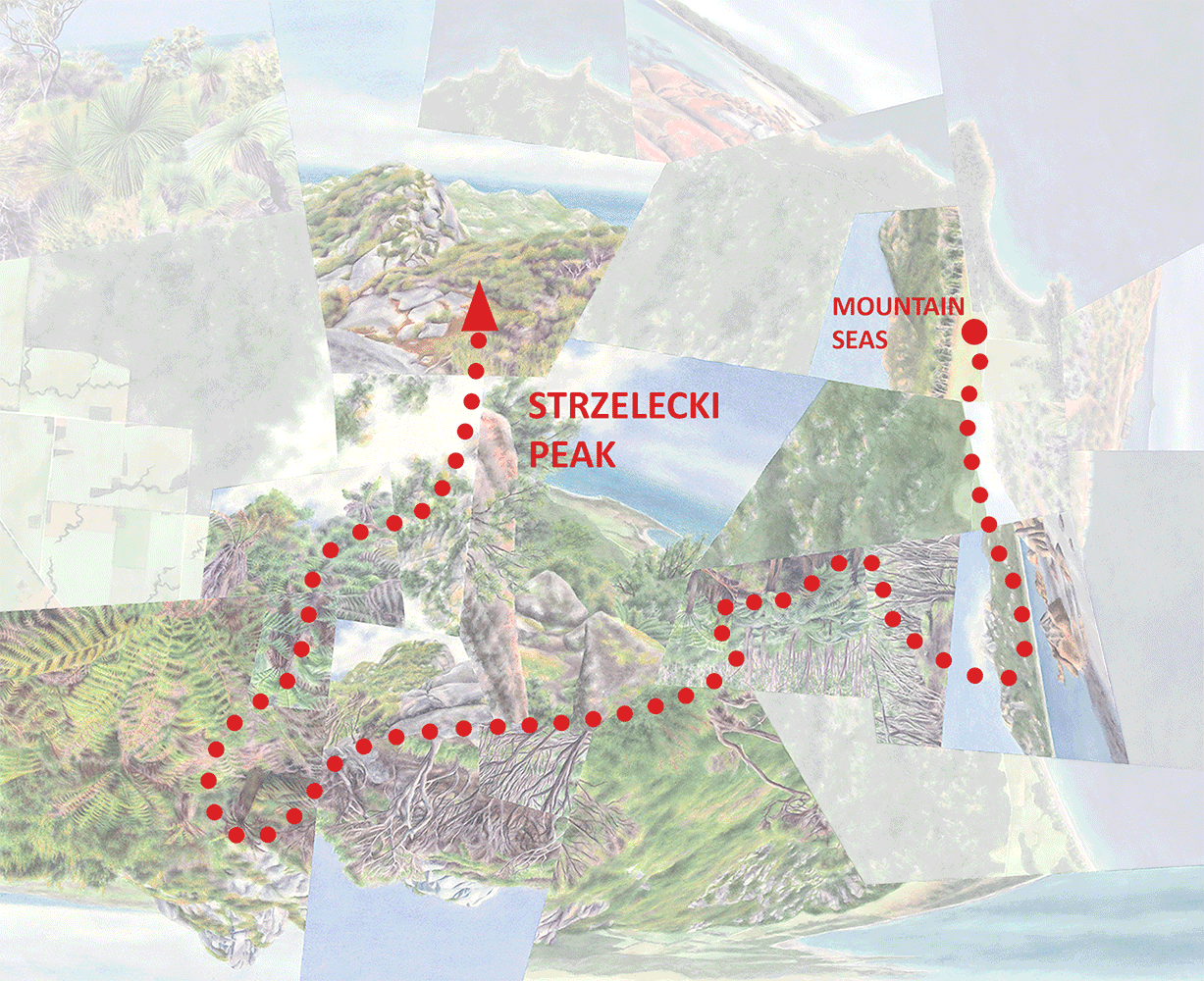
Divide (watercolor on paper, 20”x20”)—a spatially-distorted re-imagination of La Gomera’s geographical space.
Divide, though, is fully intended to be a distortion of the real thing, and of course I’ve very intentionally been calling it and my other worldviews (my views of the world) maps. Not only has the geographical space of the island been re-imagined in painted elements (added to the two axes in the diagram) correlating with the distribution of environmental elements; that re-imagined space is no longer fully linear, as indicated by the crooked arrows. Essentially each landscape view/“fragment” takes a single vantage point and blows it way up, roughly proportional to its importance in my mind based on how I experienced that spot in real life. The work is a physical map, representing a mental map of the island that’s been highly inflected by memory, preferences and value judgements, and the places I happened to visit when I was there. Geographical space has actually become psycho-geographical space—it sounds like academese but it really just means physical space that’s become distorted in the mind and then on paper by experience. (Technically all space is like that, but again I’m focusing on intent.)

Divide with path of travel overlaid in red, and the different views numbered in succession. Note that in this case travel can go in either direction.

The psycho-geographical space of Divide with “musical elements” incorporated into the two axes, adding a musical component to the route of travel through time (and space). Below I’ll say more about the musical elements themselves and what I mean by “horizontal.”
“Travel” Time (& Space)
Now I’ll get back to the issue of time—the temporal dimension of experiencing/representing a place whether musically or visually. I’ve described before how in many of my worldviews the eye and mind are meant to “explore” the places I depict in roughly linear “journeys” paralleling how I explored and remember the real locales. Though a viewer’s eyes won’t automatically follow the path I intend them to, as you’ve seen I often take the opportunity to highlight the route I had in mind when creating the work. On La Gomera and in Divide that was a generally north-south journey across the island from wet to dry.
A hypothetical piece of music, playing out in time to evoke the spatial but equally temporal experience of exploring some aspect La Gomera, could trace the same journey as the dotted red line (or a different one for that matter). In that case the visual (painted) elements, and in turn the environmental elements that vary with distance in geographic space, would be correlated (in some way that’s been chosen by the composer) with musical elements that evoke those spatial variations. Of course these musical elements don’t really “exist” in that 2D space in a meaningful way except along the travel route, where a musical composition would essentially bring them into being and to our ears. Everywhere else they exist only as potentialities—options “out there” for the composer to select where (and when) they intersect with a chosen musical path through time and space.
If it’s thought of as a musical in addition to visual journey, that path needs to run in just one direction (unless you do some fancy things with a recording). And to make it more comparable to The Last Island (in ways you’ll see later) I’ve also added the aerial views into the sequence of experiences and extended the route to double-back on itself and return northward to the wet part of the island, importantly not suggesting part of a physical journey but rather an imagining or reminiscing.. So this end part of the journey would be purely psychological not just for the viewer-listener but also for someone physically traveling the earlier part of the route.
Musical Elements, Horizontal & Vertical
So what are these “musical elements”? I haven’t done enough research to know whether there’s considered to be a “correct” breakdown or if one is even possible. But for my purposes now and especially the next post, I’ve made an attempt at a categorization that can inform an analysis of musical “spatiality” or “dimensionality” in general and in relation to how I’ve composed The Last Island. I’ll get more into it next time (they may now seem like somewhat arbitrary distinctions and divisions), but essentially I think of those elements as tempo, duration (incorporating rhythm and articulation), key (key change and duration, and key “mood” or “brightness”), pitch (range, diversity and register), instrumentation, voices (the number of different musical “lines” playing simultaneously), and dynamics (volume). There’s also the broader concept of motif or theme, corresponding partly but not entirely with “melody,” which is inflected by these other elements. Motifs, inflected in various ways, can be used to structure a musical composition into sections or “zones” just like environmental elements can be organized into ranges that structure a place like La Gomera into temperature, precipitation, or vegetation zones on an ecological map, or as I’ve done with the landscape fragments in Divide, “experiential” zones.
To better organize my thinking I’ve classified these seven elements (putting motif on a higher level) into four general categories that include various combinations and aspects of the elements:
MOTION (tempo, duration, key, pitch)
TEXTURE (duration)
COLOR (duration, key, pitch, instrumentation)
WEIGHT (voices, dynamics)
These aren’t perfectly distinct from each other and like the seven elements I don’t claim they’re “correct,” but in the process of working through my thinking they have been holding stable—some indication that they aren’t arbitrary.
Again each of the seven musical elements can correlate, however the composer chooses, with environmental/visual elements that vary horizontally (as in parallel with the ground, not just left-to-right on your screen) in a 2D representation of the earth’s surface. This means that just as the viewer’s path of travel (like the dotted red line in Divide) through psycho-geographical space passes though various combinations of those environmental/visual elements, a piece of music tracing that same path passes through various combinations of those musical elements that also vary horizontally as the music plays out. This horizontal variation through time and space happens to align with the horizontal dimension of a musical score on the page.
So then what does the vertical dimension of a printed score (or of music generally) represent? I’ve spent some time trying to figure out if there’s any agreement on what can be classified as vertical vs. horizontal components of music, and there doesn’t seem to be. It does seem clear, though, that as on the printed page, these two dimensions have some reality, and that musical elements exist on some fuzzy continuum between horizontal and vertical. Tempo and duration—reliant on the passage of time (and when overlaid on the map, movement through space) for any meaning—are clearly horizontal, but most elements are some mix of vertical and horizontal, and all are horizontal to some degree because by definition they vary over time. Pitches, for example, create various effects through vertical stacking (roughly, harmony) as well as being spread out horizontally on the page and as the piece plays out (roughly, melody, depending on how prominent the musical line is). One way to visualize the difference is through another cartographic analogy. On any map using various colors, values (black to white), or patterns (e.g. lines or dots) to illustrate zones of different elevations, climates, or any characteristic, all those colors, values, or patterns have a flat, “horizontal” component because they fill spaces spread across the page. But only the patterns are dependent on the sizes of the shapes they fill in; a given spacing of lines or dots wouldn’t show up in a space that’s below a certain size, while for color or value it would make no difference. Similarly a one-second snippet of music would probably give no meaningful indication of tempo or note duration but would provide at least a one-dimensional—vertical—indication of pitch or instrumentation. (Of course, just like the space on the map couldn’t be so tiny that the eye can’t perceive its color, that snippet of music would need to have some minimum duration; you can’t eliminate horizontality completely.)
Applying this concept of horizontal and vertical dimensions to my four broader categories of elements, it turns out that motion and texture are purely horizontal (incorporating duration and tempo plus the time-dependent aspects of key and pitch), while color and weight contain aspects fitting into both the horizontal and vertical dimensions. For the sake of space and simplicity I’ve used these four broader categories to label the musical axes, horizontal and vertical, on the diagrams.

Divide again, with a representation of an actual musical score aligned with the path of travel through time (and space). Here the vertical musical axis has been added in, and the horizontal axes are now more literally horizontal (lying flat). Note that this vertical axis has nothing to do with a vertical visual or environmental axis (representing, say, topography)—that’s been compressed into the 2D painted representation.
I pointed out earlier that the musical elements could be considered to exist throughout 2D (horizontal) space as potentialities, waiting to be picked up by a composer’s “path of travel” through it. Now that I’ve shown how an actual musical score fits into the 3D system, you might ask if there could be any printed musical equivalent to the horizontal 2D plane. For traditional music I think the answer is no. But there are contemporary scores, like some by John Cage, that are meant to be read and performed like “maps.” They’re collections of marks, often without any connection to standard musical notation, arrayed across the sheet like an abstract painting. The idea is for the performer to produce whatever sounds they evoke as the eye wanders across them in no particular direction. You could say that the marks represent these potential musical elements waiting to be picked up, with the route of “travel” created in real time rather than in advance. So what would the vertical element be in this case? I think that each mark would have its own vertical component, represented by dynamics and other aspects of the various elements as I explained above, but this would not be part of the score itself—unless the composer wanted to try somehow scoring the piece in 3D. You could also imagine multiple copies of the “map” layered vertically, each taken by a different performer; that would create multiple “routes” winding through the 2D space, layered vertically.
Multi-Media: Combining the Visual and Musical for the Listener
This whole idea of aligning musical and visual journeys on an actual map of some sort (in Pictures at an Exhibition it would be a map of the art gallery) raises the question of how visual imagery could be integrated into the act of listening to music meant to evoke a spatial journey (whether it’s a recording or a live performance). The Last Island combines the orchestral sound with an animation of still images representing the visual component of an imaginary island ascent, though as I mentioned in my last newsletter I do plan to explore other means of integrating the visual and musical media. Theoretically something like the 3D model above could be part of a presentation/performance if the viewer-listener could “fly though” it virtually as with digital architectural models.
The idea that you might use the model as part of the work/performance rather than just an explanatory tool also makes me wonder if there could be more creative possibilities for depicting the musical path itself. One might be making the path discontinuous as I’ve shown in the modified model below, if pieces of that journey are “psychological detours” like the extended end of the La Gomera path where the mind can jump around on the map however it wants. Another could be designing the journey to pass through multiple parts of the map simultaneously, along parallel paths or branching paths. That would represent, say, half the orchestra evoking one place while the other half simultaneously evokes another. The Last Island does that in one spot (sort of) as you’ll see later, but a more established example might be Borodin’s On the Steppes of Central Asia which actually was part of my inspiration for writing The Last Island. The piece is built on two melodies, one representing a group of Russians and the other a group of Mongols as they approach and then pass one another on the steppes. The melodies first alternate, then are played simultaneously. I can imagine somehow modeling this as two separate musical/visual paths of travel on a map, flowing in opposite directions through time and space.

A modified musical route through Divide, with the gap and disjointed piece at the end evoking a mental “jump” back in the direction already traveled.
But since The Last Island, for the time being, relies on animated still images to accompany the music, for a smooth segue between this post and the next one I’ve translated my hypothetical musical depiction of La Gomera into a similar sequence of still images:

Divide deconstructed into individual views (numbered at the bottom per the map) that could be animated to accompany the hypothetical musical composition as in The Last Island. The two horizontal axes from the model and maps above, representing psycho-geographical space, are here merged into a single axis that still incorporates both musical and visual (painted) elements. Those elements vary in tandem as the listener-viewer travels forward through time (and space) in the direction of the dotted red arrow representing the straightened-out travel path from the map/worldview. The vertical musical axis stays vertical, aligned with the score. All the arrows have become straight lines because geographical space here is one-dimensional—itself more of a path than space.
So that’s the theoretical framework, again mostly for the sake of getting it laid out in writing and in front of some eyes other than mine. If you’ve gotten this far and particularly if you have musical or cartographic leanings, any thoughts on whether it’s 1) intelligible and 2) interesting (maybe it’s all common sense once you think about it?) would be greatly appreciated!
Next time I’ll go into how my vision of the journey depicted in The Last Island drove my arrangement of the various musical elements in the orchestral composition.
Darren