


In my last post I took a brief detour from the “long” dry-to-wet gradient along the Ecuadorian coast to mention the fog forest of Machalilla National Park—by all appearances a “rain”-forest in the middle of that latitude’s typical semi-desert/dry forest ecosystem. The cold ocean current that’s largely responsible for Pacific South America’s unusually extensive arid zone also produces persistent fog in those same arid regions for about half the year. From central Ecuador to central Chile, wherever the topography has the right height and orientation to capture it, the fog supports comparatively lush islands of green.
Just like the drier landscapes surrounding them, these “fog-scapes” take different forms depending on their latitude. That’s partly due to topographical differences and local variations in fog conditions, but since “actual” rainfall (i.e. not fog) falls on both the highlands and the lowlands, you could say that this fog-scape pattern is generated by two scales of precipitation gradients overlaid on one another—the “long” north-south rainfall gradient and the “short” topography-generated fog gradients. (Note that in this Climate Journeys series I’ve been using “rainfall” and “precipitation” interchangeably, though in this post the former is more appropriate since “precipitation” includes fog drip.)

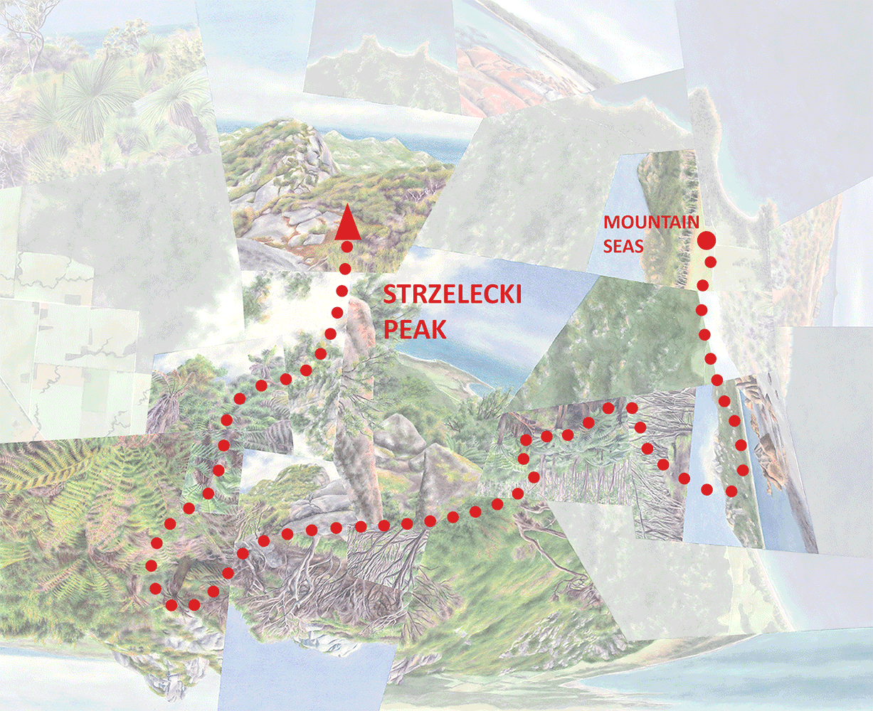
Four types of fog-scapes along the overall north-south climatic gradient. The dashed arrows on the right give a very rough approximation of where, in terms of precipitation, each fog-scape would fall along the overall (~sea level) gradient.
I’ve written about a few of these environments previously—this post will summarize and situate them within the larger-scale rainfall gradient and introduce a few others. (Because of topographical variation they don’t quite form a continuous chain down the coast, but many more than these exist.) I probably don’t need to say again that I find these environments thrilling, and am surprised they aren’t more well-known.
“Fog Forests”
The fog-scapes at the northern end of the rainfall gradient, inland from the coast of central Ecuador between 400 and 800m of elevation, once again are true forests, taller and more luxuriant than the surrounding dry forests. They’re like the cloud forests we typically think of but unlike, say, rainy Monteverde in Costa Rica, they wouldn’t exist at all without the fog (called garúa in Ecuador and Peru). The effect of the fog is self-reinforcing in that the trees themselves intercept a great deal of it, which then slowly drips to the forest floor.
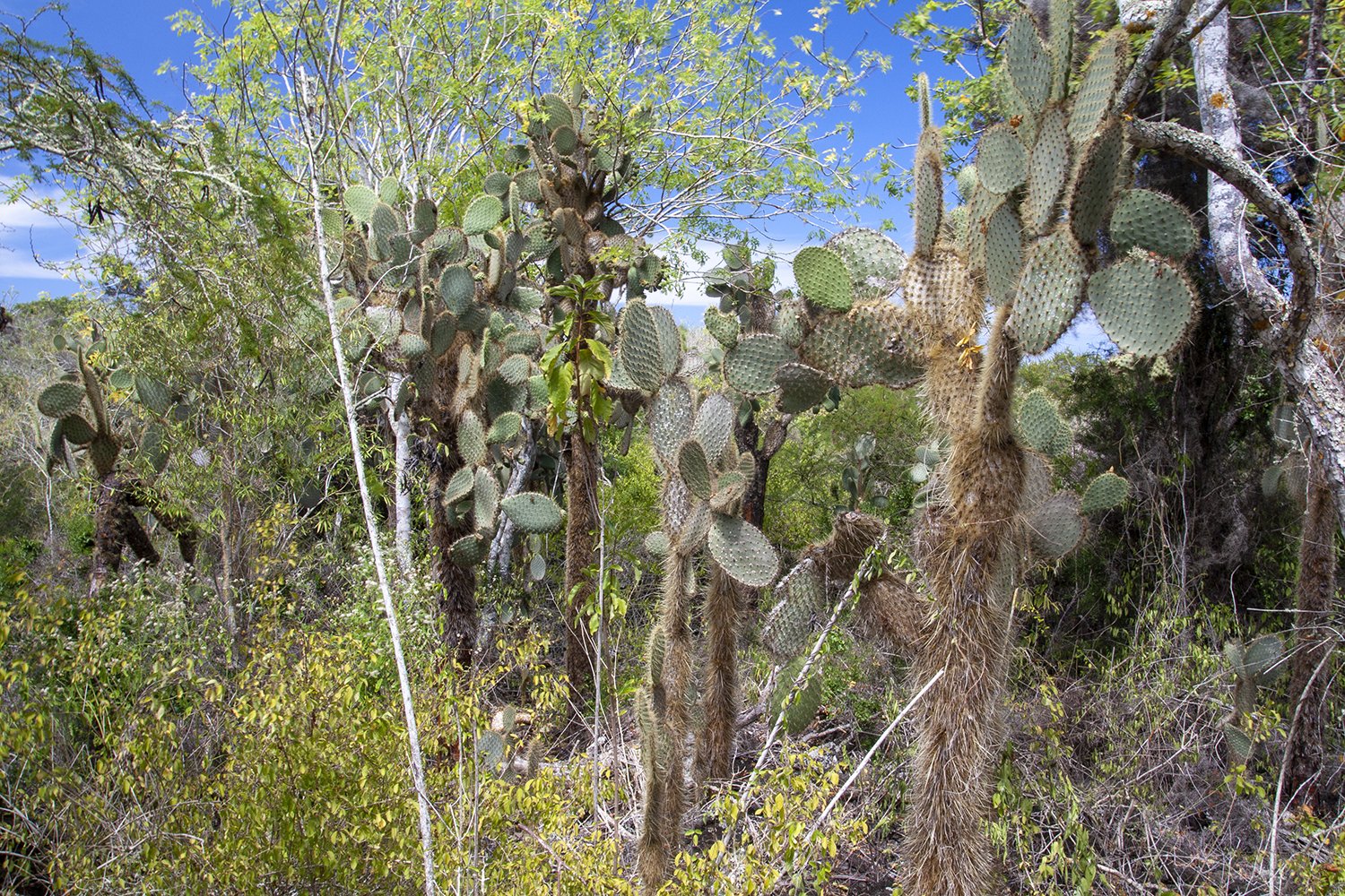
While they’re about 900km from the mainland and I haven’t seen the relationship made explicitly, you might say that the wet highland forests of the Galápagos Islands also fit into this fog forest category (or at least the tiny fragments that still exist). The Humboldt/Peru Current flows past the islands as it heads westward away from the continent, essentially drawing them into the mainland rainfall gradient. The arid lowlands of the archipelago could generally be considered part of the same semi-desert/dry forest zone as the central coast of Ecuador; the primarily garúa-dependent highland forests (beginning as low as 300m above sea level) would be the fog forest equivalent. Like all Galápagos environments though, these forests are very distinctive, with low stature and species diversity; they’re formed exclusively by trees in the endemic genus Scalesia. (For a lot more detail on Galápagos vegetation zones, including the surreal too-wet-for-trees zone above the forest, check out my post on Santa Cruz Island.)
Lowland dry forest/semi-desert on Santa Cruz Island in the Galápagos....

…and Scalesia forest in the highlands.
“Fog Oases”—Peru
Along the coasts of Peru and northern Chile where rainfall drops to just an inch or two a year, the fog-scapes are called “fog oases,” “fog meadows,” or lomas (“small hills”). The near-absence of rainfall means that these landscapes are much more sparsely vegetated than their counterparts in Ecuador. The Lomas de Lachay a few hours north of Lima (inspiration for Fog Meadows) resembles a meadow or savanna, with only scattered trees even in the wettest parts. There is a continuous carpet of herbs and grasses, shockingly green (and specked with wildflowers) during the winter compared to the complete desolation beyond, but all of that turns brown during the fog-less season.

My photo of somebody else’s photo of the Lomas de Lachay at the height of the fog season, overlooking the desert below. You can find a bunch of my own images here.

Another “fog meadow,” the Lomas de Lucumo, this one right in the city of Lima. This one’ll also make it into watercolor at some point.
“Fog Oases”—Chile
In Chile these environments tend to have a very different character, without the trees or green carpet. The difference is probably explained by less persistent fogs (in Chile called camanchacas) compared to Peru (according to The Phytogeography and Ecology of the Coastal Atacama and Peruvian Deserts, a great description for anyone who wants to get into the weeds on this). The plants—most notably cacti but also bromeliads and woody shrubs at the higher elevations—are more clumped or scattered, somewhat like the wetter semi-desert areas to the south and in the Andean foothills to the east. Pan de Azúcar National Park, in the southern Atacama, is one of the best examples in terms of species diversity although (as with all of these fog-scapes) I didn’t catch it at the best time of year.
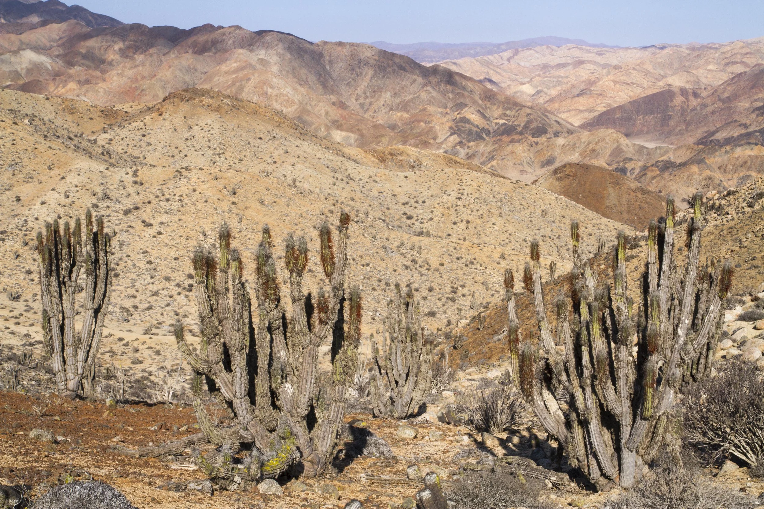
The uplands of Pan de Azúcar, more lifelike during the foggy season.

The cacti are draped with lichen—here dried out—at higher elevations.
“Valdivian Rainforest”
Continuing south to about 400km north of Santiago, rainfall increases again and the typical landscape transitions to cactus-filled semi-desert, though by North American standards it’s still quite desert-like (resembling the Sonoran to a degree). Again topography and local fog patterns probably play a role, but I’d expect that the higher rainfall has a lot to do with why the fog-scapes in this region, all found as far as I know in the hills of Bosque Fray Jorge National Park, do contain pockets of actual forest in the highest parts (~400-500m). They’re dense and evergreen, with plenty of moss and lichen, but I wouldn’t call them rainforest-like even though they’re considered to be disjunct islands of “Valdivian rainforest”—the name given to the Chile’s temperate rainforest zone to the south. (Incidentally the subpolar rainforests beyond that are called “Magellanic.”) That does suggest some true affinity, plus the forest probably would’ve felt more luxuriant during the fog season. But that classification could also be a less formal one based on species affinity rather than strong ecological or climatic similarity—the predominant tree species in Fray Jorge is common (in much more massive form) in the temperate rainforests.

A few of the arid coastline from the highlands of Bosque Fray Jorge. The patches of forest (like in the middle-ground) are interspersed with zones of shrubs and bromeliads (foreground).
(There’s a lot more to say about Fray Jorge, and as I shared in my last Newsletter I’ve recently completed a worldview that it inspired—that’ll be my next post!)
“Hygrophilous Forest”
This one I actually haven’t been able to visit, but it rounds out the discussion well since as far as I can tell it represents the continent’s southernmost fog-scapes, around the latitude of Santiago where the influence of the coastal fog belt peters out.
Moving south into the subtropical shrubland (Mediterranean) zone, the fog supports “hygrophilous” forests (the term, which I hadn’t come across before, means “damp”). Like Fray Jorge’s forest pockets these forests are evergreen and have close affinities with the temperate rainforests to the south, though in this case I haven’t seen them referred to as “rainforests” themselves. Unfortunately I can’t speak to their atmosphere in that regard, from experience or from photographs (of which I haven’t found any). According to the only description I’ve seen of these forests, the best examples are found in west-facing valleys in La Campana National Park, about 50km to the northwest of Santiago and from the coast. I did spend a few days there but didn’t know at the time that these forests existed. They do receive more rainfall than Fray Jorge and have an abundance of lichens and epiphytes including Spanish moss (actually species a bromeliad), so my guess is that they do have a more rainforest-y aspect. Whether they could give my diagram a nice symmetry as the temperate equivalent, precipitation- and character-wise, of Ecuador’s fog forests would be interesting to know.
Another comparison might be to the SF Bay Area’s redwood forests, which are also highly dependent on fog and are located in another subtropical shrubland/Mediterranean zone (though with slightly higher rainfall…Santiago is at the equivalent latitude of Los Angeles). These I’ve also seen classified as “rainforests” by some and not others, depending on whether “rain” is taken to mean “precipitation” in general.
Given that I only had the chance to visit a small number of these fog-scapes, and not at the ideal time of year, I’d really like to put together some sort of creative project to explore/portray them as a unit—which I haven’t seen done before, even just in text—and at their most evocative. I think it would make both a more feasible and a more interesting proposal than, say, my long gradient transect idea. Plus, though I haven’t seen detailed predictions, I think it’s pretty certain that (with the context of their dry surroundings) these ecological gradients/contrasts are going to be easily and heavily affected by climate change, given the fog-scapes’ tiny scales and the finely-tuned climatic meteorological generating the region’s fog patterns.
Darren