


To give you—and myself—a break from the more academic tilt of recent posts, this time I’m going to write about a particular place/worldview as I’ve done in most of the earlier entries in this blog. And while I still plan to tie up loose ends with the “musical cartography” and “long gradients” topics in the near future, of course there’ll be more of these place-focused posts as I keep producing work and hopefully start to travel again….
This one will deal with Robinson Crusoe Island, in the Juan Fernández archipelago about 400 miles off the central coast of Chile. (Daniel Defoe’s novel was inspired by the adventures of the sailor Alexander Selkirk after he was marooned there.) There are two other islands in the archipelago, but only Robinson Crusoe is inhabited and simple to visit—“simple” being relative though given that the trip requires a very expensive and erratically-scheduled flight from Santiago. I went there, with thankfully no scheduling issues, at the end of my month-long trip to South America in fall 2019.

Robinson Crusoe Island, with wet east side and dry west side (the barren areas east of the main ridgeline muddle the picture a bit—they’re generally the result of deforestation and erosion rather than aridity).
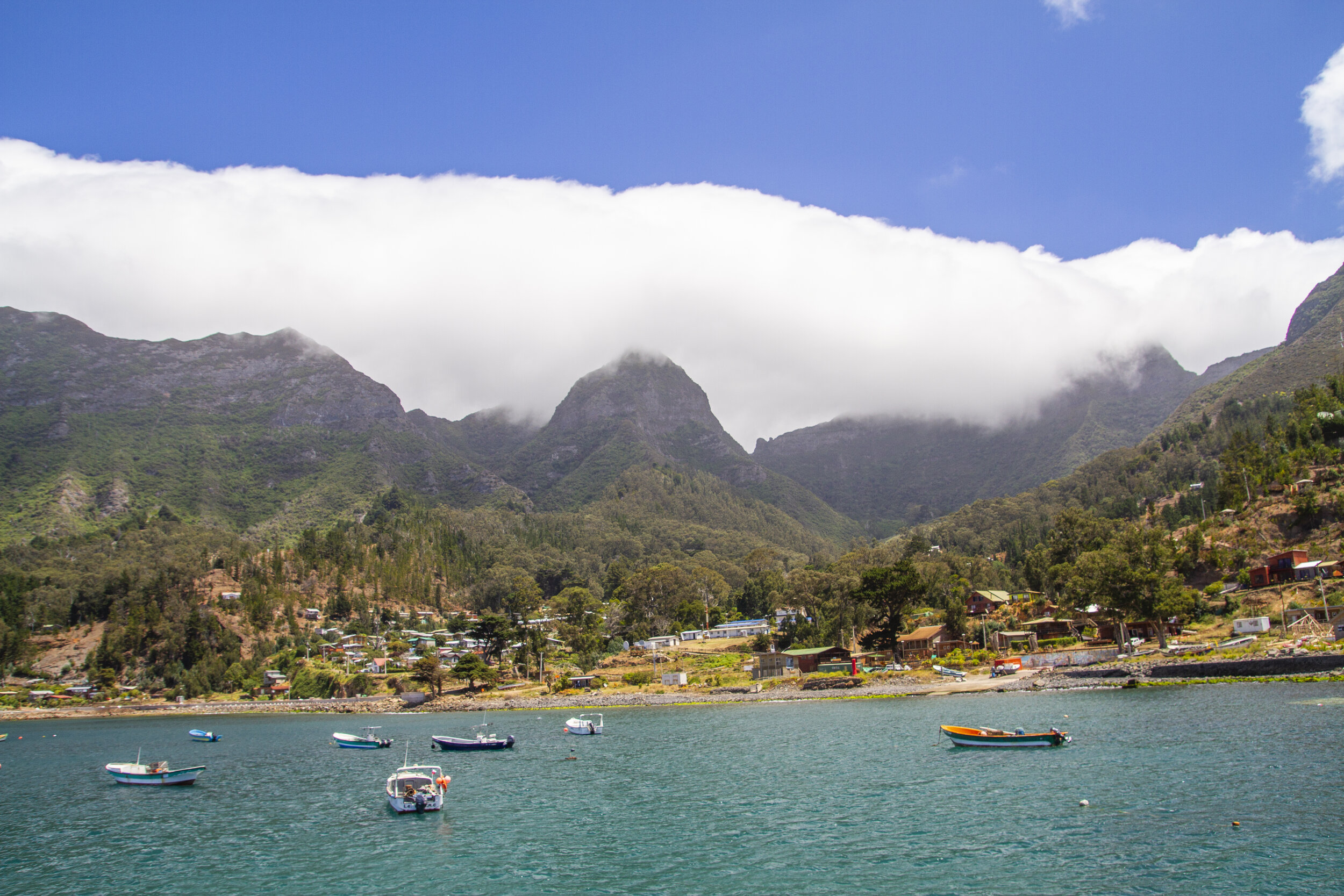
San Juan Bautista, the only population center in the archipelago, on the east coast of Robinson Crusoe with the island’s main ridgeline behind. This coastline has a Mediterranean climate, but essentially all of the island’s native lowland vegetation has been removed or replaced.
One reason for going was my usual obsession with sharp ecological contrasts on islands. Unlike the imaginary one depicted musically in The Last Island, Robinson Crusoe is relatively small and low, covering about 20 square miles and rising to just over 4000’, and so it doesn’t rise to alpine heights; but the topography is dramatic, generating a rainfall gradient from sea level to the ridgetops as well as a striking rain shadow effect across the island’s western peninsula. The other attraction is an endemic palm, Juania australis, very ornamental but notoriously difficult to cultivate. It’s one of Chile’s two native/endemic palm species, the other being the much better-known Chilean wine palm (Jubaea chilensis) from the mainland.

A rare specimen of Juania australis in the cloud forest.

Me with another palm specimen in habitat.
Unfortunately both of these features of the island, and other aspects of its biological richness (its rate of endemism is higher than that of the Galápagos) are less salient than they once were. Deforestation, invasive plants and animals, fire, grazing, and erosion have greatly reduced the extent of native ecosystems and heavily degraded the pieces that remain. That was especially evident at the eastern end of the island (the area around Cerro Pascua on the map).

Panoramic near Cerro Pascua, where a combination of deforestation and runaway fires (lit intentionally, though I forget the reason—I don’t think this area was planted or grazed) has left all of the lowlands and much of the highlands barren and eroded.

Wooden dams have had some effect on slowing erosion in these gullies.

One of the pockets of forest that has escaped the fires.

Even where the tree canopy remains, the understory is completely bare and dessicated in most places due to foraging by exotic animals, especially rabbits.

Another forest pocket, in this case cloud forest, clinging to the ridgeline.

Large areas of forest have been mostly taken over if not replaced by invasive trees—in this view, that includes all of the bright green on the lower slopes (the native trees are more purplish).
That was all very depressing to see. Luckily though, I had an extremely knowledgeable and accommodating guide who made it all very worthwhile and brought me to a few of the more pristine, harder-to-reach areas. One of those is a pocket of relatively intact cloud forest (images following) without an official trail, below another part of the main ridgeline near Cerro Damajuana. (The palm images above are also from this area.)


You can see a few scattered palms in the lower right.
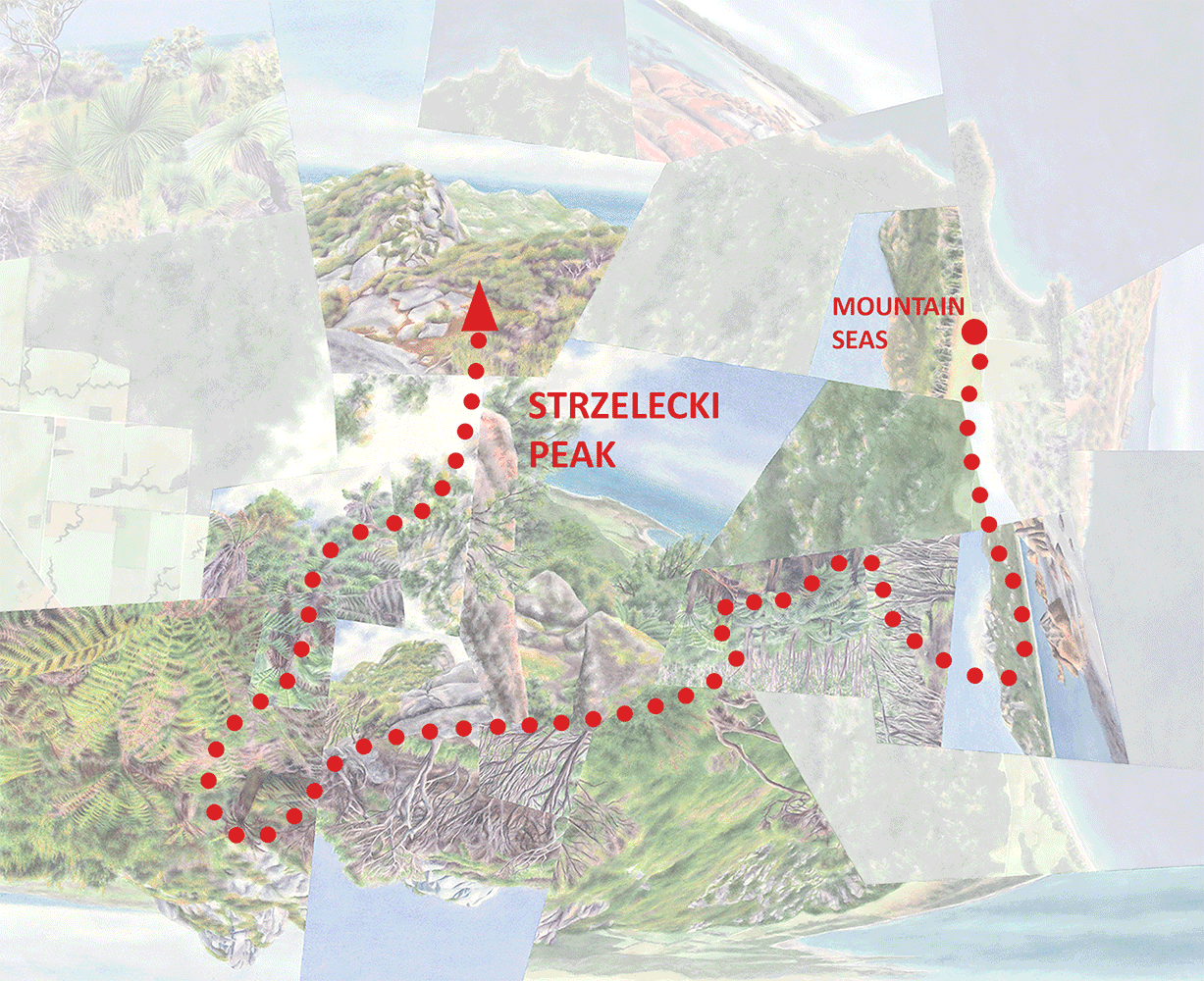
My visit ended with a roughly six-hour hike between the wet and dry sides of the island, from the town on the east coast to the airport (and my flight back to the mainland) at the western tip. Technically it began at Mirador Selkirk, an observation point on the main ridgeline; the uphill route from town is entirely through exotic vegetation and given the limited time until my flight I traveled it before sunrise. But even across the ridgeline few parts of the overall route have escaped degradation, including what must’ve originally been a transitional dry forest/savanna zone at the lower edge of the forest. (From earlier posts you’ll know that I find ecotones like this to be especially entrancing, but they’re particularly (and for me frustratingly) susceptible to human impacts given that they tend to be both topographically accessible and wet enough to be useful for non-preservation purposes.) But despite this, the contrast between the extremes is probably just as striking as it used to be.

View across the cloud forest to the arid western tip of the island, from Mirador Selkirk (an observation point) on the main ridgeline. Pockets of the forest ahead are in decent shape but essentially everything behind, from the town up to and including the ridgeline vegetation in the foreground, is exotic. And, like on the eastern part of the island, the bright green vegetation is also not native.

A relatively intact area of cloud forest just below the ridgeline.

Looking back at a few Juania australis on the ridgeline, one of the few places where clusters of them have been able to survive (elsewhere it’s just one here and there).
A bit further downslope, with an endemic species of Gunnera in the foreground.

Dropping below the forest into (non-native) grassland and ranchland. This zone might’ve been naturally treeless, but was definitely more structurally and biologically diverse.

Moving further west as the landscape becomes progressively drier.

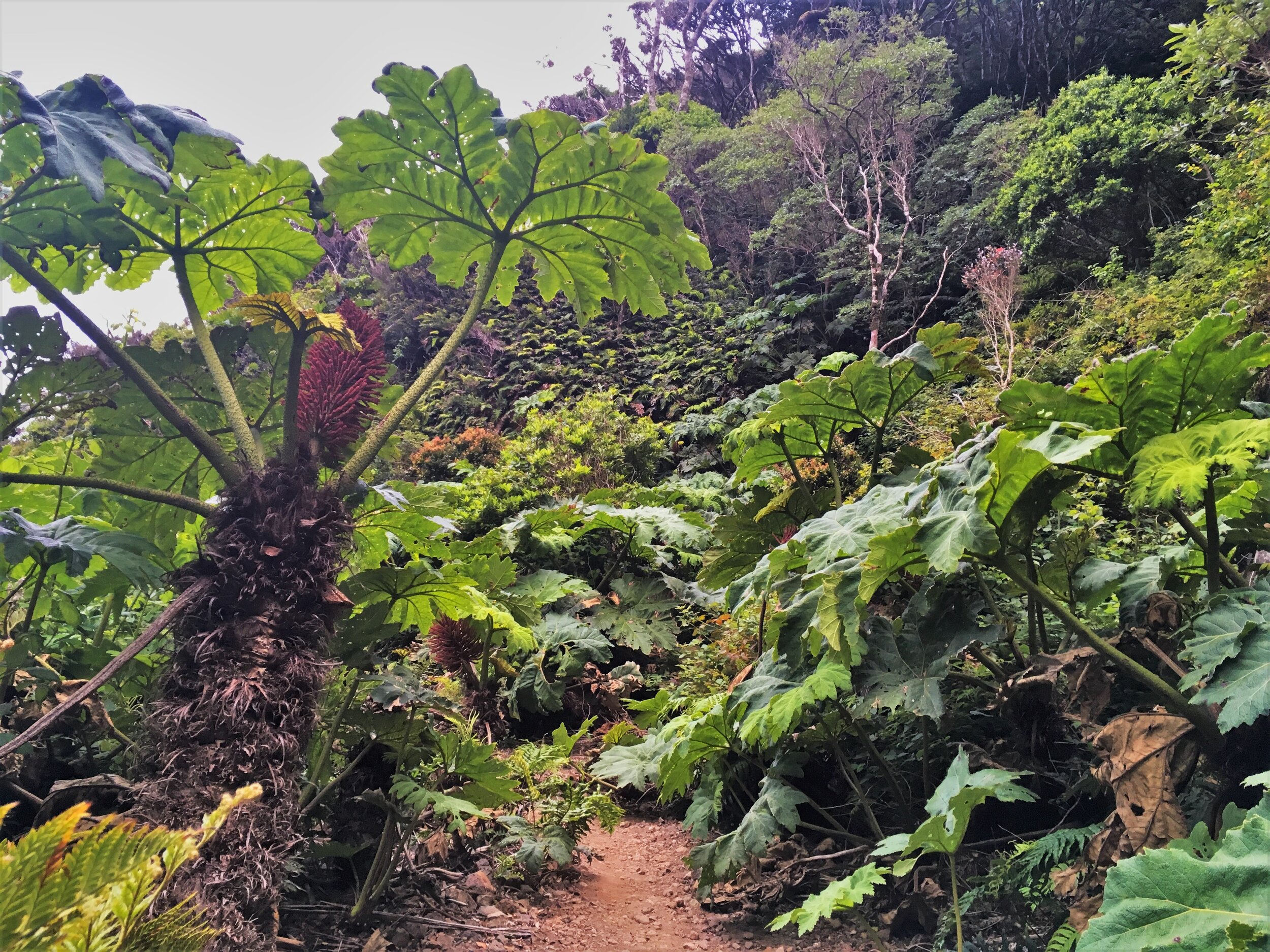
A few rainforest species, like these tree ferns, hang on in scattered spots of the dry zone where there’s groundwater.

The hike ends at the airport, in the desert at the western tip of the island.
Mirador, the one watercolor so far inspired by Robinson Crusoe, traces this journey from wet to dry (but oriented bottom-to-top). The distinction between intact and degraded vegetation is more ambiguous in paint than in real life, but I do play up what I imagine the landscape might’ve looked like by “restoring” it in places where the difference would stand out. (You might notice that a few of the views borrow from other parts of the island.)
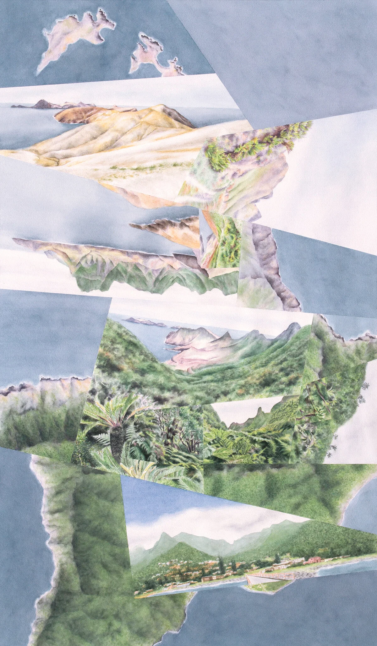
Mirador, watercolor on paper, 48”x28.”

The journey from wet to dry (bottom to top), animated view-by-view.
It was interesting to compare impressions from Robinson Crusoe and the Galápagos, in terms of environmental value and situation. Both places have extremely high rates of ecological diversity and species endemism that face serious challenges from human activity. The Galápagos is more famous given its charismatic fauna and its Darwin-associated history, plus the fact that such a high percentage of its environment is relatively pristine (or at least can be perceived as such); if or when its species and landscapes start falling off the edge in ways that the tourists can’t overlook, I know it’ll be a gut punch for me and most people who are conscious of these things. But on Robinson Crusoe I found myself wondering: If or when these last remnants of cloud forest are taken over by invasives or dried out by climate change, how much will that truly matter, to me and to anyone else who’s paying attention? (The island residents themselves seem relatively conservation-conscious nowadays, but they don’t live their lives lamenting what’s already been lost or depressed about what might be to come. Most visitors probably see things the same way, and maybe even most biologists.) There are plenty of other places that are much further gone, and the world has easily moved on….
Darren
